|
 For
a while I’ve been asking myself how it’s possible that I keep
finding new natural wonders to write about after 25 years of
living near Guadalajara. So, one day I sat down with a map and
drew a circle around the city, with a radius of around 250
kilometers, nicely encompassing the places a citizen of
Guadalajara could conveniently drive to in one day. For
a while I’ve been asking myself how it’s possible that I keep
finding new natural wonders to write about after 25 years of
living near Guadalajara. So, one day I sat down with a map and
drew a circle around the city, with a radius of around 250
kilometers, nicely encompassing the places a citizen of
Guadalajara could conveniently drive to in one day.
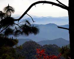
As I looked over what was included in that circle, I realized it
was filled with attractive, picturesque, exciting, charming,
even amazing sites. There was Lake Chapala, biggest lake in the
country, the Primavera pine and oak forest, the live and fiery
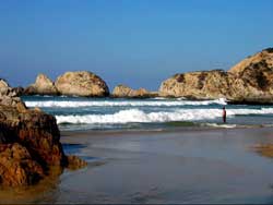
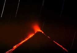
Volcán de Fuego, the white sand beaches of the Pacific Coast,
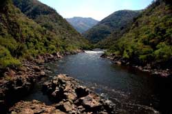
huge, deep canyons carved by the Santiago River, limestone
mountains supporting incredibly rich cloud forests like El Cerro
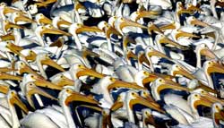
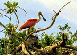
de Manantlán, the mangrove swamps and rivers of San Blas,
teaming with bird and animal life, and much, much more.
Of
course, to some extent, this variety can be attributed to
altitude, which ranges from the height of snow-covered Nevado de
Colima (4240 meters, 13,911 feet) to sea level on the Pacific
coast. But is this diversity of eco-systems due only to
altitude?
By good luck, I happened to receive a copy of just the book that
could answer this question. I’m referring to
Geo-Mexico, by Richard Rhoda and Tony Burton. This is a
geography book, but far more interesting than the sort I had to
deal with as a schoolboy. It focuses on the interaction between
people and the physical environment and is chock full of
fascinating facts. For example, did you know that Mexico has
more species of pine trees than any other country? That it has
the world’s richest assortment of cacti (over 900 species)? That
Mexico’s diverse economy produces about $1.6 trillion in goods
and services every year, more than Canada or South Korea? That
Mexico’s population of 110 million makes it the eleventh largest
nation on earth? That migrant workers in the USA sent $25
billion (yes, billion!) back to their families in Mexico in
2008?
 But
I digress. This book also made it possible for me to test my
theory that the circle I had drawn around Guadalajara is
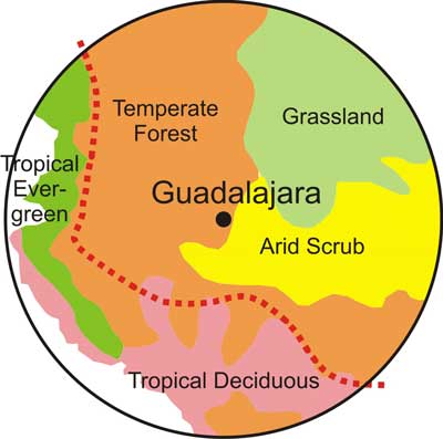
something special. Chapter 5 of Geo-Mexico is devoted to
ecosystems and biodiversity. It divides all of Mexico into five
natural ecosystems: But
I digress. This book also made it possible for me to test my
theory that the circle I had drawn around Guadalajara is
something special. Chapter 5 of Geo-Mexico is devoted to
ecosystems and biodiversity. It divides all of Mexico into five
natural ecosystems:
►Arid
scrublands
(as in
the cactus-rich Sonoran desert_)
►Tropical
evergreen forests
(for example, the rain forests of Quintana Roo)
►Tropical
deciduous forests
(like the thorn forests of Sinaloa)
►Grasslands
(from Ciudad Juarez to Aguascalientes)
►Temperate
forests
(the oaks, pines and firs of Mexico’s mountains)
To my surprise and delight, I discovered that there is only one
place in the entire country where all five ecosystems are found
in close proximity and that is inside of what I have now decided
to call The Magic Circle. In addition to this, according to
Rhoda and Burton, the line designating the major Faunistic
Divide of Mexico, (creatures of the north and creatures of the
south) just happens to run right through that same Magic Circle.
This is shown as a dotted red line on the map above.
Rhoda and Burton state that Mexico is one of the most
mega-diverse countries of the world, with 30,000 different
species of flora (compared to 18,000 in the USA) and, in my
opinion, the best place to get a taste of this extraordinary
biodiversity is The Magic Circle.
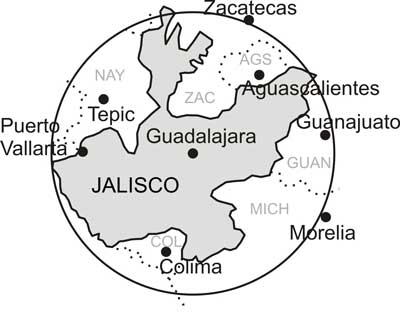
While many of us who live inside this circle see it as a single
geographical unit (the area around Guadalajara), politicians
might have a very different opinion. Politically, the Magic
Circle is composed of Jalisco plus a large chunk of Michoacán, a
slice of Nayarit, a lump of Zacatecas, a piece of Guanajuato and
the entire states of Colima and Aguascalientes. While a citizen
of Guadalajara might see a circle, a politician may see
something shaped like an anemic amoeba. Funding, of course, for
most projects related to culture, tourism or sport will usually
come from the coffers of a single state and usually result in
posters, brochures, films, etc. with titles like, The Marvels of
Michoacán, The Haciendas of Jalisco or The Calabashes of Colima.
Thus, the bigger picture often escapes the eye of the
politician—and the publisher as well. I was once asked to write
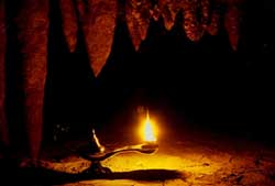
a book on The Caves of Jalisco and replied, “But amigo, some of
the best caves of Jalisco are in Colima and Michoacán.”
Apart from the fact that The Magic Circle encompasses
extraordinary geographical, botanical and biological diversity,
it also just happens to have been home to complex civilizations
for over 2000 years and because of its huge obsidian deposits,
was, for a long time, the very hub of the vast and powerful
Teuchitlán nation. So, this area is abundantly rich in
pre-Hispanic ruins like its famed Circular Pyramids, as well as
countless colonial-era haciendas.
So it is that a person living in Guadalajara Mexico could choose
from any of the following fascinating places for a Sunday
outing, and could draw up a similar list for dozens of Sundays
thereafter:
●Ceboruco
Volcano: pine trees, meadows and hissing fumaroles
●San
Blas: mangroves, exotic birds, crocodiles and dramatic
ocean surf
●Los
Negritos: boiling black mud pots next to an unpolluted deep
lake.
●Las
Piedras Bola: giant stone balls at least a few million
years old
●Santa
Rosalia: untouched, beautifully preserved circular pyramids
2000 years old
●Hacienda
de San Antonio: deep canyon, tropical orchard, idyllic
swimming hole
●Tapalpa:
mountain town with cobblestone roads, ornate balconies, cold
nights, blazing fireplaces
●Las
Siete Cascadas: seven waterfalls and natural pools all in a
row, 10 minutes from Guadalajara
●Bosque
de Maples: a Pleistocene cloud forest near Talpa,
dripping with moss
The Magic Circle around Guadalajara is almost as big as the U.S.
state of Kansas, but I doubt if you could find so many marvelous
and varied places to visit on a day trip out of Topeka… or even
out of Tokyo or Timbuktu.
If the governors of the seven states within the Magic Circle
were to sit down together and to draw up a strategic tourism
plan, the Magic Circle around Guadalajara might someday acquire
the reputation that it deserves as one of the most extraordinary
and attractive places on the face of the earth. |