 |
|
|
SIERRA DE QUILA:
JALISCO’S BIG, BEAUTIFUL
NATURE PRESERVE
By John Pint
Text and Photos ©2007 by John and Susy Pint
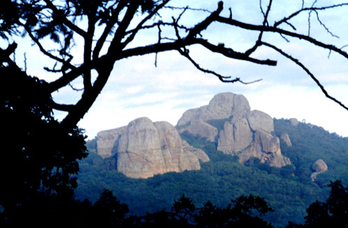
Seven years ago, some friends invited me on a trip to La Sierra de Quila, which is located halfway between Ameca and Tecolotlán, an area which, at that time, could truly be described as “remote.” We had heard about the place because my friend Andi Mohl had assured me that his rock-climbing friends considered las piedrotas of Quila—with sheer rock faces over 100 meters high—a far more serious challenge than the monoliths of El Diente, near Guadalajara.
I have dusted off that old report, removed the spots and scratches from some of the pictures (thanks to a great, free, clean-up program by Polaroid) and reproduced it below. If Quila's high rocks are especially interesting to you, or if you'd like to learn how to lose and find your grandma in a huge forest, be sure to check out BIG QUILA'S MIGHTY ROCKS just below.
|
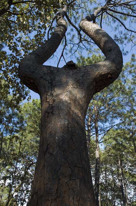
The other day, I revisited the hills of Quila with our friend Pedro Fernández Somellera. We went straight to the park headquarters, at the northern edge of Tecolotlán. Here rangers showed us computer photos of the area’s attractions. “There are eleven waterfalls in Quila,” we were told, as well as mountain peaks like El Huehuentón (2475 meters high) and curious phenomena like El Arbol de la Lira, a tall graceful tree shaped like a lyre.
|
 |
|
Soon we were
out in the forest, wandering among gorgeous,
delicate
Lumholtz's Pines
(Pinus lumholtzii), visiting several of the magnificent waterfalls
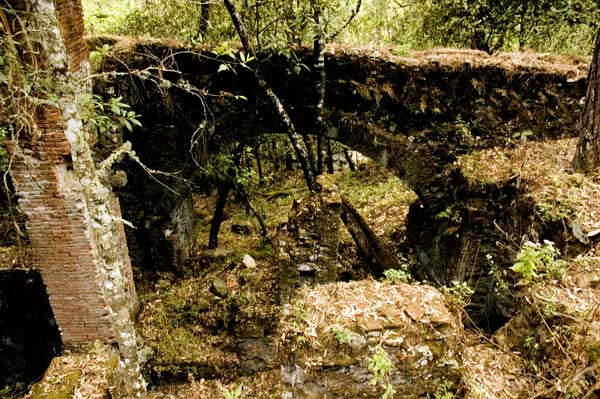
and exploring the extensive ruins of La Máquina, a water-powered sawmill
which must have been truly impressive in the days before electricity was
available. It soon became obvious to us that every inch of this forest is
dramatically beautiful and refreshing to walk or drive through.
|
 |
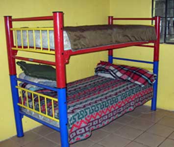 
LEFT: The park has a refuge with bunk beds, a toilet, a shower and a fireplace, but no furniture.
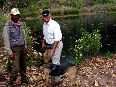
RIGHT: Our guide Rafa with Pedro and Solito at the edge of a small dam. |
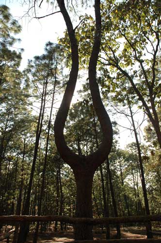 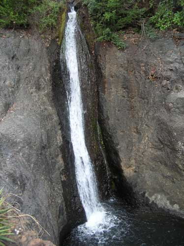
LEFT: The lyre tree
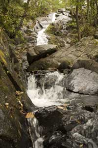
RIGHT: Cascada La Poza. The water enters a narrow channel and rushes down to a second waterfall. |
|
The protected area covers over 15,000 hectares, but it has many
roads and you can find your way around easily using a map available from the
park’s headquarters at the north end of Tecolotlán...
|
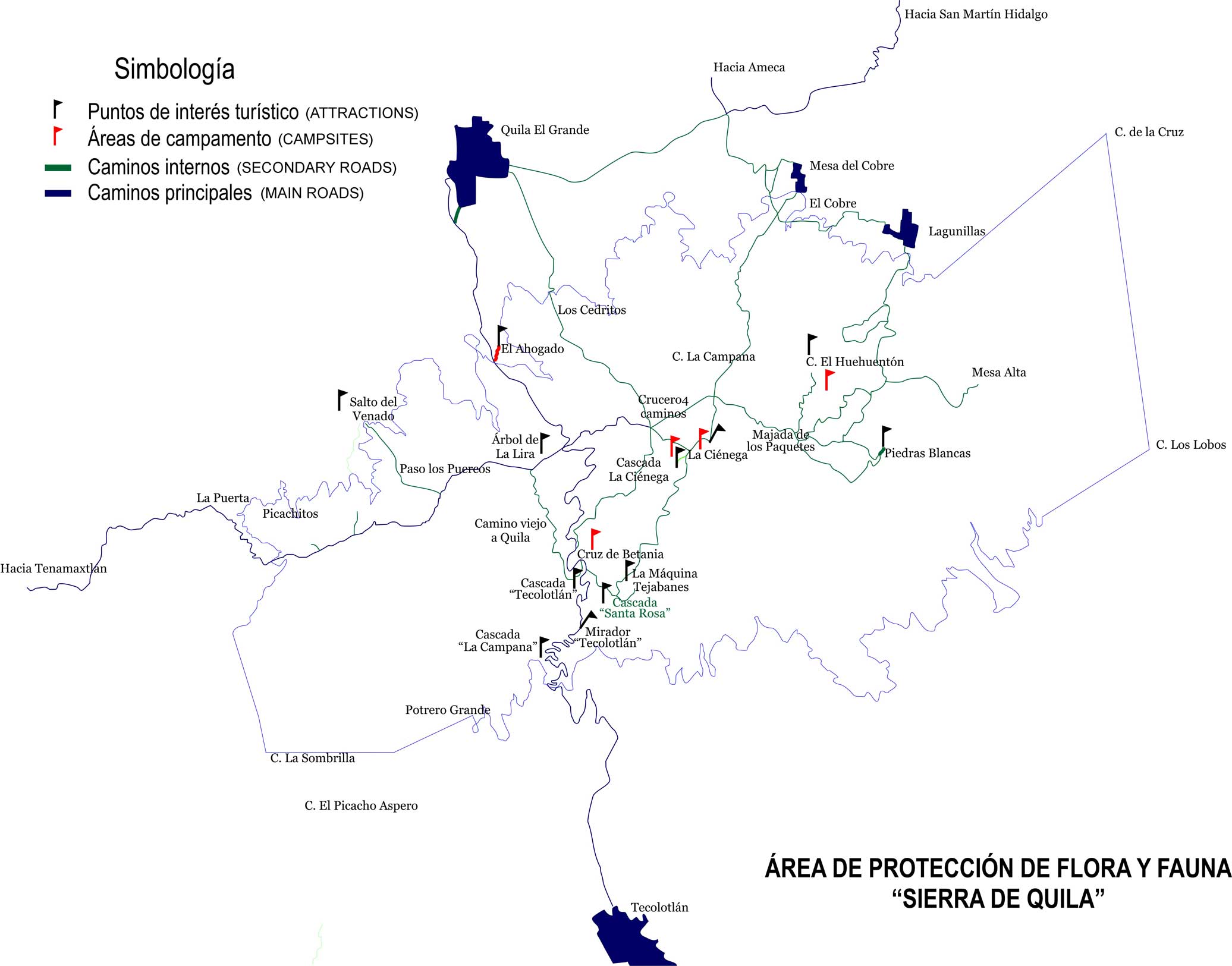 |
...Likewise, you can apply at this building for permission to camp at one of four designated sites inside the park’s boundaries. The headquarters are located at 13 Q 0598615 2234914 (if you happen to have a GPS) and their phone numbers are (52) 349 776-1171 and 776-0826.
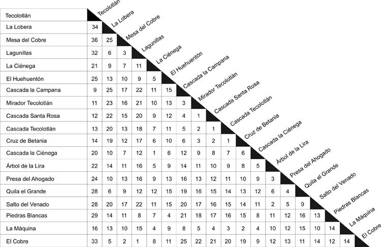
QUILA DISTANCE CHART
Shows the distance in kilometers between the park's main attractions (courtesy of Sierra de Quila Park)
|
|
How to Get There
Take highway 80 southwest from Guadalajara and follow the signs for Barra de Navidad. When you come to Tecolotlán, drive northwest through the elongated town until, at the other end, you come to a cobblestone road in good condition heading north and signposted “a Quila El Grande.” After eleven kilometers along this road, you’ll begin to see signs indicating most of the protected area’s attractions. Driving time from Guadalajara to Tecolotlán is less than two hours.
August 15, 2000
BIG QUILA'S MIGHTY ROCKS
Even Grandma will love it, as long as you don't leave her there.
by John Pint
"The monoliths at El Diente are nice," said Andi Mohl, a Mexican-German physics teacher long in love with Jalisco's Great Outdoors, "but for a real challenge, my rock-climbing friends prefer Las Piedrotas de Quila, which offer sheer rock faces over 100 meters high, making those Dientes look like pebbles."
When Andi's father, Justus, offered to organize an exploratory trip to Quila, I was delighted to be invited along. Seven of us would squeeze into the Mohl Family camper, which has found its way to nearly every corner of Mexico and even as far as Belize.
On August 6, 2000, we drove to Ameca and headed south along a well-maintained dirt road. In no time at all we had climbed to an altitude of 1800 meters from which we could see the Texcalame Dam far below us. My hosts commented that these particular hills have so many springs that they remain lush and green throughout the dry season. This explained the abundance of spreading willow trees along this scenic mountain road.
Quila is called El Grande to distinguish it from a nearby village called Quililla, but it's not exactly a metropolis. It does have a beautiful Plaza and you can even buy gas, if you don't mind it coming out of a milk can. We were told that the road leading to the town's cemetery was the one we needed to take to reach San José de la Peña, a scenic spot for camping, from which one could walk to the Piedrotas (Big Rocks).
We found the cemetery and merrily cruised along a meandering road that led us in and out of numerous muddy streams and past countless falsetes (cattle gates), each of which we carefully reclosed behind us.
Well, the road ended in a bright green, lonely meadow, muchos kilometros from the famous rocks. We then returned to the last fork and were lucky enough (on a Sunday, when you never find a campesino in the campo) to come upon a man standing at the edge of a pond with a fishing pole in his hand.
"What are you fishing for?" cried Andi, as we approached.
"Fish!" replied the man, looking at us the way country people usually look at city folk.
Although he was extremely kind to us, did I detect a glint of amusement in his eye when he told us we had been driving in the wrong direction the whole time and would have to go all the way back to the cemetery?
And back we went, through all the same streams, opening and shutting the same cattle gates. At the cemetery, we discovered that our mistake had been to turn left. We should have stayed on the road heading north.
This time we decided to ask everyone we saw along the way if we were on the right track. Thus it was that we ran into a picturesque vaquero on horseback who introduced himself as Alfredo Jiménez. "Most folks trying to find those rocks use my children as guides," explained the cowboy. "I live at Independencia Street #7, just in case you need my kids," he commented, as if he suspected we might soon need them indeed and in fact, on more than one occasion in the next hour, we were tempted to go back and take up the offer.
|
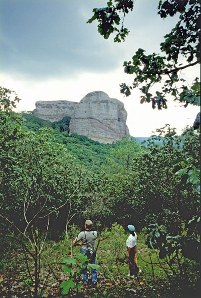
For example, at a beautiful wrought-iron gate which incorporates
several ancient wagon-wheels into its design, we had been instructed to "go
straight ahead (ir derecho." Now, did this mean "Go straight past"
said gate or "Go straight through it?" The latter proved true and several
falsetes later we found ourselves on top of a broad, grassy lookout,
face to face with the huge rock outcrop we had been seeking so long. We then
ate our sandwiches to fortify ourselves for what looked like a long hike,
the entire Mohl clan ready to blaze a trail over hill and dale to reach the
peña, even though black clouds were beginning to form overhead.
|
 |
We found a trail which looked like it hadn't had a lot of use recently and headed downhill toward a little stream where a falcon on a low branch sat and waited until we were almost upon it, before flying off. Crossing the stream, we headed up a long slope, admiring the white estrella flowers, which, I was told, only appear after a rain. In the evening, the same flowers give off a heavenly aroma.
At the top of the hill, Andi's grandmother declared that she had reached her limit: "You go on ahead and I'll wait here," she said, so I duly took a GPS reading and named that spot "Granma" to be sure we'd find her again on the way back (GPS means Global Positioning System. The handheld device is the size of a cell phone and pinpoints your location by tracking satellites).
|
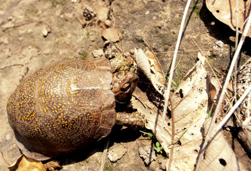
A little further up the hill we found a large (12 cm) turtle
lumbering alongside what little was left of our trail. A turtle on top of a
cerro and Granma missed the sight! Next we came to a barbed-wire
fence and prepared to roll under it -- but a yellow-red-and-black snake,
well over a meter long, had already occupied the place. As it slowly
slithered away, it vibrated its tail, producing a quiet buzz.
|
 |
|
Now the rocks were looming above us, but it was getting late. We
decided to head back and to pick up Granma. However, to our surprise, we
found no one at the official Granma GPS site.
|
 |
"She must have started back on her own," we concluded and headed down the hill -- but three-quarters of the way back we still hadn't seen a sign of her. So I turned around, tromped back up the hill again and began shouting, Granma! Granma!" up and over the top of the hill. Finally, I decided she simply wasn’t there, but I gave one last shout... and heard a feeble reply from just ahead of me. Granma had surfaced, just in time!
The next morning we got a good look at the Big Rocks jutting above a sea of white clouds. Then the same clouds rose and we drove back to Quila surrounded by thick fog.
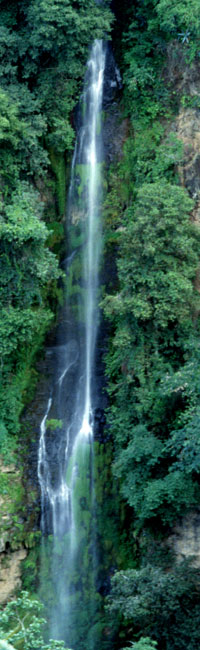
Our next goal was to have a look at El Salto de Tecolotlan, a high waterfall that we were told was "only twenty minutes" away. We drove in a southerly direction on somewhat worse roads than those we'd seen so far. At every other dip we seemed to find puddles, streams or lagoons to cross, but the worst were the long stretches of deep mud in which the unstoppable camper would slowly drift sideways as the mighty 4WD engine churned away. After an hour and a half, we finally came to a beautiful pine forest where we could hear the splashing of water coming from a deep gorge off the side of the road. A short walk along a cliff-side trail gave us a great view of El Salto which turned out to be one of two mighty cascades practically next to each other. People say it is possible, but difficult, to climb down to the bottom of the falls for a swim. Bear in mind that these were the same people who said the waterfalls were only "20 minutes" from town!
The falls are located right off a wide, well-maintained cobblestone road that took us (without a single mud bath) south to Tecolotlán from which we made our way back to Guadalajara.
HOW TO GET THERE (The route from Ameca)
Take highway 15 towards Nogales/Tepic and turn left before the toll road, onto the highway to Ameca. At Ameca, look for the Quila sign which gets you onto a divided street heading south, passing a military base. Quila is 30 kms straight ahead. In Quila you can hunt up Alfredo Jiménez's kids at Independencia 7 or you can ask for the road to the cemetery (panteón) and drive due north out of town, straight past the cemetery. After a half hour or so, you'll come to the brightly painted red-and-white, wagon-wheel gate. Go through the gate, across a small stream and through several barbed-wire falsetes which may require a bit of untwisting (bring pliers!) until you are on top of a broad hill at 20° 24.10 N, 104° 07.32 W with the Big Rocks clearly visible to the west.
El Salto de Tecolotlán is at 20° 16.53 N, 104° 03.77 W, most easily reached via the "Super Empedrado" road from Tecolotlán (about an hour's drive). Total time from Guadalajara to the lookout campsite: about three hours if you're lucky.
|
|