|
By John Pint
 “There
are interesting rock formations in the Primavera Forest between
Río Salado and Tala,” I was told recently by Mario Guerrero, who
has been hiking and camping all over Mexico since he was a boy.
I figured if he considered a rock interesting, it ought to be
curious indeed, if not bizarre. And I was right. “There
are interesting rock formations in the Primavera Forest between
Río Salado and Tala,” I was told recently by Mario Guerrero, who
has been hiking and camping all over Mexico since he was a boy.
I figured if he considered a rock interesting, it ought to be
curious indeed, if not bizarre. And I was right.
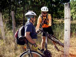
Mario, his friend Arturo Tejeda and I, headed for the Salty
River via the western entrance to the Primavera Forest off
highway 70. Mario’s objective was “Cañada Incognita,” a pretty
canyon he had begun to explore, which, he said, we could reach
“in 20 minutes” by bicycle.
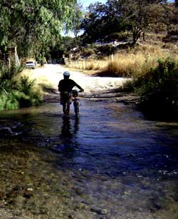
We walked our bikes across the warm, shallow Río Salado, which
is what Río Caliente is known as after it cools down a bit. Then
we passed the cycles through a hole in a barb-wire fence, right
under a sign saying “Private Property.”
“Don’t worry,” commented Mario, “that just means cars aren’t
allowed in here.” I could see this was going to be another
typical Mexican Adventure.
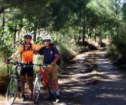
I somehow assumed a “20-minute” ride means we’d be following a
flat road. Well, the dirt road was wide and smooth, alright, but
flat it was not and it took a full two hours to reach Mario’s
Unknown Canyon. When I pointed out the time discrepancy, I was
told, “Bueno, we would have made it in 20 minutes if you hadn’t
stopped to take so many pictures.”
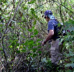
We hid our bikes off the side of the road and headed into an
impenetrable wall of underbrush. “Miseria,” said Mario, “last
time I came here there was no maleza at all; lucky I brought
this machete.” Ah, yes, a true Mexican Adventure.
While Mario furiously hacked at the maleza, Arturo—who was
wearing shorts—complained that mosquitoes were eating him alive.
“I can’t stand it! I’m cycling back home,” he announced and
left. His home, by the way is in Tesistán, 22 kilometers away as
the crow (but not the bicycle) flies. I did not get a single
mosquito bite, which I attribute to the vitamin B Complex I take
every day, which I highly recommend, because the dengue-carrying
Aedes Aegypti is all over Guadalajara and was recently found at
the outskirts of the Primavera Forest.
Dripping with sweat after advancing only two meters, Mario gave
up his chopping and we backtracked to the site of the mysterious
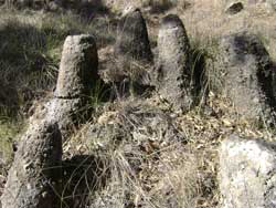
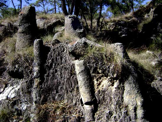
rock formations. These I have seen before in the Tala area where
we named them “Fairy Footstools” (See Reporter, July 18, 2008).
They look like tree stumps, about one foot wide and up to two
feet high, but are composed of volcanic rock (rhyolite,
apparently). What I found special about Mario’s find was that,
because of road construction and subsequent erosion, the
subsurface part of one “footstool” has been exposed, showing it
to be a vertically oriented column of rock with a consistent
diameter. While in the Ahualulco area, we have Piedras Bola
(Great Balls of Rock), in certain areas around Tala there are
mini-forests of these “Rock Footstools, sometimes numbering in
the hundreds.
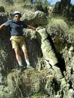
So how were these curious columns formed? Local geologist Chris
Lloyd suggests they are “Bubble Trails” marking the places where
gas bubbles rose through a cooling pyroclastic flow (an
incandescent cloud shot out of a volcano at high speed),
provoking crystallization. Eventually the degassing pipe gets
completely full of particles which may later solidify and end up
being much harder than the surrounding material, eventually
standing out as pinnacles, columns or even lowly footstools.
After sending pictures of these formations to other geologists,
I learned that they are often called “fossil fumarole pipes” and
examples can be found in Alaska, Oregon, Australia and
elsewhere.
Instead of traveling to Alaska, however, you can see a lot of
these Rock Pipes simply by taking a 4.5 kilometer walk (or bike
ride) south of the Rio Salado.
We also found a very interesting trail only 3.7 kilometers from
the river. This is a true hiker/biker’s delight, shady and
narrow, which parallels a small river past all kinds of
bizarrely shaped rocks, including some of those curious Fossil
Fumaroles. We followed the trail for 450 meters till time
constraints forced us to turn back, but we definitely plan to
return and see where it goes.
By the way, we saw no cars, ATVs or human beings during our
odyssey in “Transaladania,” my new name for the area south of
the Río Salado.
How to get there
Take Highway 15 (Nogales) 25 kilometers west of the Periférico
to Highway 70 (Ameca). Don’t get on the toll road by mistake! Go
southwest on 70 toward Ameca for about 3.5 kilometers at which
point you are about to cross over or detour around a bridge
under reconstruction. Immediately after crossing over or under
the bridge, turn left onto an unmarked dirt road heading
southeast. Follow the main drag until you come to a fork with a
big sign advertising a balneario. Along the way, you may be hit
for a small “car fee.” Don’t go to the balneario, but bear left
and you’ll soon come to some lavish buildings (private property)
where you’ll now have to pay a ten-pesos-per-person fee. About
280 meters southeast of this point you’ll pass a fenced-in pool
full of big fish and you’ll see the Río Salado dead ahead. Park
next to the pool, cross the river, step through the convenient
rectangular hole in the barb-wire fence and head southwest on a
dirt road. After 1.9 kilometers, you’ll see a side road. Keep
going straight. Next you’ll come to a big green, locked, iron
gate with a convenient bypass for hiker-bikers. At 2.9
kilometers from the river you’ll see a road heading left, but
you continue going straight. At 4.5 kilometers you’ll at last
come to the exposed Fossil Fumarole Pipes (GPS N20 39.587 W103
37.145 datum WGS84). Walk due north from here to see a lot more
of them.
Driving time from Guadalajara to the river crossing is less than
one hour. This is also reachable from the Lake via Jocotepec,
Santa Cruz and Tala. The turnoff to the Primavera Forest
entrance road (dirt) is about 11 kilometers northeast of Tala.
If you have a GPS, you’ll find this turn at N20 43.580 W103
37.159.
|