|
By John Pint
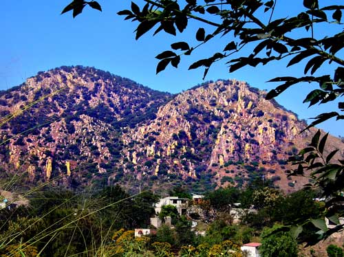
The
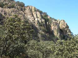
little town of San Esteban—located only seven kilometers north of
Guadalajara—is overshadowed by a steep mountain bristling
with
tall, rocky spires as numerous and as pointy as a hedgehog’s quills.
Many
years ago, I went to San Esteban trying to reach the top of that
picturesque mountain, and along the way fell in love with the town
itself, whose charm I’ve described in the book Outdoors in Western
Mexico (now available in a new edition):
“I beheld
dogs barking,
chickens cackling, pigs rooting, children frolicking, cows ambling down
the unpaved street, a decrepit truck clanking its way through the
potholes, loudspeaker on the roof announcing luscious papayas (papaws)
and the cheapest onions anywhere. Moreover, each back yard we passed
offered a new feast for the five senses. There were groaning
clotheslines swaying in the breeze, seeds drying in the sun, an old,
old lady patting tortillas, skeletons of long dead cars sprouting
bright flowers and climbing vines ── plus the mouth watering smells of
carne asada (roasted meat) and bubbling salsas.”
I paid a new
visit to San Esteban not long ago and I’m happy to report it is as
quaint as ever, even though the road is now paved and the number of
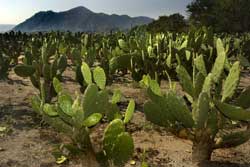
homes has grown. The town’s prosperity, I suspect, is due to the nearby
fields of nopales (prickly-pear cacti) which stretch for kilometers and
kilometers to the north. These are cultivated for their tender “leaves”
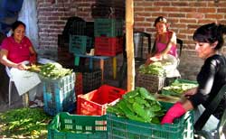
called nopalitos,
which, I discovered, the local ladies can “deprickle”
faster than your eye can follow. It’s worth going to San Esteban just
to watch these women at work and I suggest the town ought to start
holding an annual Nopalito Festival and Deprickling Contest. Actually,
Mexicans have so many delicious ways to prepare nopalitos that I think
this would really work.
 If, in
addition to folklore and
nopalitos,
you are also up for a strenuous climb to the monoliths
above, I’m happy to report that I have at last found the elusive trail
which you need to follow. If, in
addition to folklore and
nopalitos,
you are also up for a strenuous climb to the monoliths
above, I’m happy to report that I have at last found the elusive trail
which you need to follow.
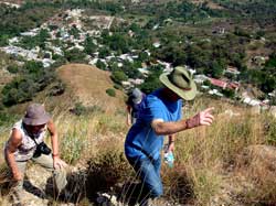
The trailhead is a concrete stairway
on the roadside, 735 meters north of San Esteban’s church (actually,
it’s a chapel). The stairs took us right up to the chicken coops of a
private home, whose owner assured us we were on the right track. “Take
the trails that head up there,” she said, pointing southwest. We walked
one minute and the path split. “Take the upper one” shouted the Señora
of the house, who was still watching us, and this turned out to be good
advice in general. Up is the way you want to go! It’s not
mountaineering, but the path is about as steep as a path can get.
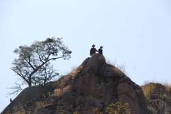
Passing
three clumps of scrawny trees, we came to rocky outcrops we had to
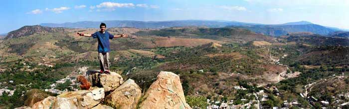
scramble up. In a bit under an hour, we were “on top,” that is, we
reached a magnificent lookout point from which we enjoyed a
breathtaking view, including a peek at Guadalajara’s skyline in the far
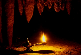
distance, just beyond the magnificent Barranca de Oblatos. Our
belvedere also turned out to be an archaeological site, even including
what appeared to be a looted tomb. It was a tough climb, but well worth
the effort.
How to get there
Go north on Prolongación
Alcalde. Once you leave town this becomes highway 54 heading for
Zacatecas and Saltillo. Nine kilometers after crossing the Periférico,
you pass under a footbridge followed by a sign announcing the entrance
to Fraccionamiento Las Cañadas (formerly San Isidro). Bypassing the Las
Cañadas entrance, take the immediate following left turn. After three
kilometers, you will find yourself in the center of San Esteban and in
the shadow of the spire covered hillside. As you pass the church, set
your odometer to zero. Drive 735 meters north and park near the
stairway, which you’ll see on your left. The lookout point you are
trying to reach is to the southwest at coordinates N20 48.225 W103
22.719. Driving time from the Periférico to the stairway is about 25
minutes.
|