 The
GPS:
The
GPS:The
GPS:
Friend or Foe of Desert Caves?
What can it do for you?
Should you get one?
By John Pint
When I lived in Saudi Arabia, I discovered that the GPS has both a
bright side and a dark side and even though the device has evolved over
the years, it continues to be a source of both good and evil for this
little old planet of ours.
| The entrances to many of these cave systems,
however, were often small holes only 50 centimeters around and
relocating one of these holes in a “featureless” (to everyone but a
Bedu) desert, was like trying to find a bread crumb in a sandbox. You
could literally be standing three meters from the entrance to a major
Saudi cave and not see it at all. If you want to know just how
difficult it was to get around in the desert in the past, see The Joy
and Terror of Caving in Arabia in the Early Days. Susy Pint in the entrance to Surprise Cave...not so easy to find without a GPS. |
 |
But along came the GPS, a navigation device that receives signals from
the Global Positioning Satellites originally put in place by the U.S.
military for their own purposes. At first they deliberately distorted
the signals so the accuracy of the thing was limited to 100 meters—only
if you were a civilian, of course. What this meant was that in the
desert, we often had to drive back and forth across a 200-meter-wide
circle in order to find our cave—but we did it without complaint.
Then, in May of 2000, the U.S. Armed Forces reluctantly turned off
their “fudging machine” and GPS units all over the world were suddenly
accurate to within about three meters. What used to take days before
the GPS now took minutes: it was incredible!
Only much later did we discover the evil Jinn that lives inside the
GPS. People would go out in the desert, discover some marvel like a
half-buried mammoth tusk, an area full of sharks’ teeth or a cave full
of delicate formations and the next day they’d email the coordinates to
their friends—all of them nature-lovers, of course. Emails, however are
soooo easy to forward and eventually the coordinates would reach The
Bad Apple…or maybe in Arabia we should call him The Rotten Date, and
this individual would forward that email to his less-ecologically
oriented friends, maybe the kind of people capable of breaking off and
carting away every last stalactite in a cave or covering the walls with
graffiti.
|
What Hath the GPS Wrought in Saudi Caves?
|
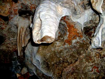
Mahmoud Al-Shanti shows broken stalactites in Surprise Cave |
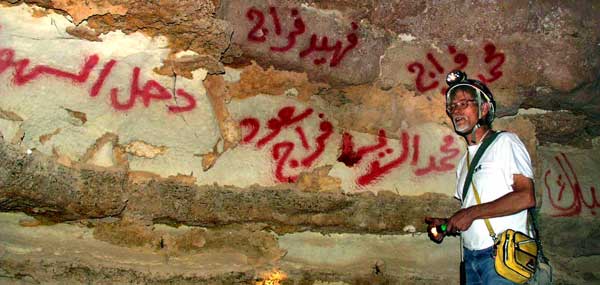
John Pint trying to wish away the graffiti in Murubbeh (Shawiah) Cave. Photo P. Forti.

One of two human skulls later stolen from Murubbeh Cave, almost certainly with the help of a GPS.
Should I Buy a GPS?
Assuming that you are not a cave vandal, let me share what I know about
whether or not you should buy a GPS.
Let’s say you are a person who enjoys hiking off the beaten track, as I
do. First of all, the main benefit of a GPS made for hikers is, in my
opinion, that it automatically records every step you take. So, if a
local guide takes you along a convoluted route to a heavenly swimming
hole in the middle of a chaotic lava field, you’ll be able to go back
there on your own next week or five years later. You just have the GPS
save this “track” and pass it to your computer for future use. The
automatic recording is also useful if you happen to get lost. You just
turn on the “trackback” feature of your GPS and it will faithfully lead
you back to your car or wherever you came from.
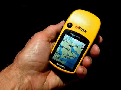
These features are found in small units about the size of a cell phone,
made for hikers and boaters, such as the different models of the Garmin
Etrex. Most of these models now feature “high sensitivity” (HC in
Garminese), meaning they work quite well under tree cover or inside
cars.
On the downside of the many hikers’ GPS’s made by Garmin and other
companies, is that every one I’ve ever seen is so user-unfriendly that
you really have to put in time to figure the thing out. Like so many
modern electronic marvels, these gizmos were designed by nerds for
nerds and they just can’t resist giving you 10,000 options you really
don’t need.
Conclusion: if you like to wander about in the boonies, you’ll get a
lot of benefit out of a hiker’s GPS, but if you’re the kind of person
who needs to ask someone else to put a new entry into your mobile
phone’s address book, forget it. Otherwise, go out and get yourself an
Etrex (with HC, of course). You shouldn’t have to spend much more than
US $100 for one.
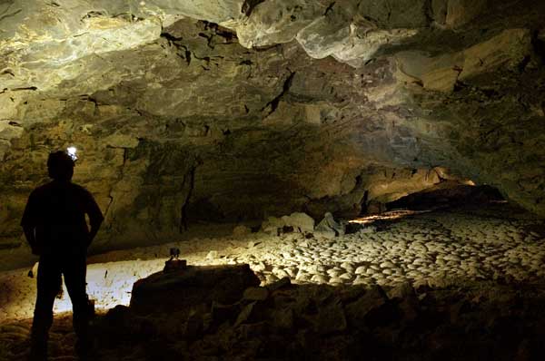
Umm Jirsan Cave, lost deep inside Harrat Khaybar Lava Field. Without a GPS, we'd have a hard time finding it.
The
Talking GPS
Now let’s talk about the “car GPS.” Unlike those mentioned above, it is
designed to be super user-friendly and to do everything automatically.
It has a big, full-color screen, talks to you in a variety of voices
and accents and costs just a little more than a hiker’s GPS. These
babies are made to be used on streets and established roads and they
talk you to your destination most efficiently. My travelling-musician
brother[link http://www.pintndale.com/], William Pint swears by his
TomTom for navigating the streets of London or finding his next venue
in large and small towns across the USA and Canada. “TomTom is the
easiest, most reliable GPS I've ever used,” he says. It has been
dead-on accurate, simple, elegant and a pleasure to use.” I must add
that even my computer-allergic sister Ruth easily reaches destinations
in Denver and all around Colorado guided by her smooth-talking TomTom.
On the downside, these talkative marvels are not designed for hikers
wandering along a cow path in the mountains of Mexico (I tried). Nor
should their authoritative-sounding directions be trusted in situations
where a mistake could be fatal.
A case in point is the tale of John and Starry Rhoads, an Oregon couple
in their 60’s, who, according to Canada’s Globe and Mail, spent three
days stuck in the woods when their talking GPS directed them down a
remote forest road on Christmas day, 2009. The friendly female voice of
their car GPS led them 40 kilometers along an unmaintained road in a
wildlife refuge until they got totally bogged down in snow. Garmin,
which manufactured their unit, later released a statement reminding
customers that “directions offered by the device are only suggestions.”
The Rhoads were more fortunate than a British woman who drove her
$200,000 Mercedes into a river while following GPS directions.
According to the Globe and Mail, she was pulled from the car before it
was swept away.
In spite of all this, the GPS is not only here to stay, it is—like the
Internet and Google Earth—destined to creep into every nook and cranny
of your life and will in short order be incorporated into your
wristwatch, your cell phone and probably your belt buckle. Getting lost
will be a thing of the past…and who knows? Once you have that GPS, you
may even decide to join Mohammad Al-Fares for
geocaching
in the desert!